Kemijoki River

Kemijoki supersite

About the supersite

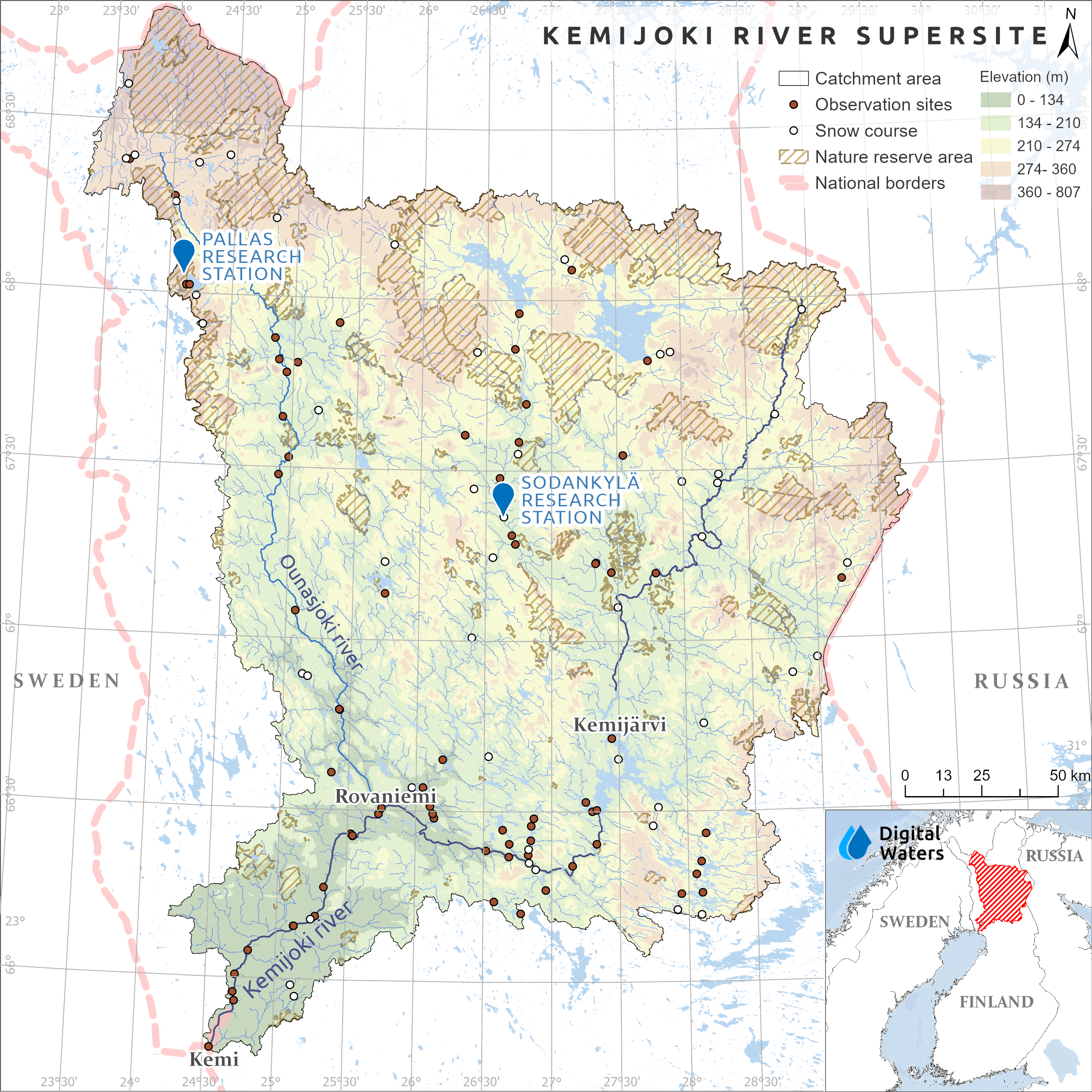
The Kemijoki River supersite consists of the Kemijoki watershed, Sodankylä Research Station, and Pallas Research Station.

The Kemijoki watershed is the largest watershed in Lapland and the second largest in all of Finland. The main river channel of the watershed is the Kemijoki River, which is both the largest and the longest river in Finland. The river flows through the cities of Sodankylä, Kemijärvi, Rovaniemi, and Kemi to the Gulf of Bothnia.  

Unique features
The Kemijoki River main channel is highly regulated. There are 16 hydropower plants in Kemijoki River, seven of which are among the largest in Finland.

The Kemijoki River Supersite combines basin-scale hydrological modelling, covering the entire river basin, with advanced monitoring and research infrastructure to improve the understanding and prediction of northern hydrological systems. Research focuses on improving river runoff forecasting by integrating detailed snowpack and hydrological models with emerging machine learning approaches. As snowmelt plays a key role in northern river systems, special attention is given to understanding how snow cover influences hydrological processes and river dynamics. The supersite provides valuable knowledge to support more accurate predictions of water resources and changing environmental conditions in northern regions.

The Sodankylä and Pallas Research Stations are key research environments within the Kemijoki River Supersite, providing long-term observations and advanced infrastructure for studying snow processes, hydrology, and water–carbon interactions in northern ecosystems. By combining field measurements, remote sensing, isotope techniques, and modelling, researchers investigate snow accumulation and melt, water movement, and ecosystem processes in Arctic and subarctic environments. The resulting long-term datasets support the development and validation of hydrological models and contribute to a better understanding of northern water systems under changing environmental conditions. 

Kemijoki Watershed

Kemijoki Watershed is a test area for large-scale hydrological modeling and runoff forecasting from satellite-based measurements. 

Sodankylä Research Station

The Sodankylä Research Station hosts several measurement sites in different environments, such as boreal forest, wetland, lake, and open tundra. The station is operated by the Finnish Meteorological Institute. The station strives to create an integrated view of water and carbon cycles in an Arctic-boreal environment. This is done using a combination of remote sensing and in situ measurements. 

At the station, long-term snowpack monitoring is conducted, process models and remote sensing methods are tested, and interactions between carbon and water cycles are studied. At the station, snow measurements have been taken over 100 years.  

Pallas Research Station

The Pallas Research Catchment is a 5 km² catchment in north-western Lapland, 130 km north of the Arctic Circle, adjacent to Pallas-Yllästunturi National Park. With limited human influence, it features a small stream draining forested hillslopes and diverse wetlands, including open fens, treed mires and paludified forests. Shallow upland soils and deep peat deposits shape its hydrology, representing a typical northern boreal ecosystem near the transition to permafrost-affected palsa mires. 

Research at the Pallas focuses on water–carbon interactions, hydrological and biogeochemical processes, microbial activity, stable water isotopes, and catchment-scale snow hydrology. As over 40% of annual precipitation falls as snow, the site provides valuable data for studying cold-climate hydrology. These long-term observations support advanced hydrological modelling and improve understanding of hydrological processes in subarctic environments. 

Modelling

Satellite-based modelling of streamflow, soil temperature, and soil moisture.

Snowpack monitoring

As a water source for hydrological modeling. 

Monitoring, sampling & remote sensing

Hydrological monitoring, water isotope sampling, and UAV-based remote sensing to investigate biogeochemical processes, microbial activity, and water quality.

Data collection

From multiple sources, using satellite data, reanalysis data, and in situ measurements.

  • Spring snowmelt forecasts are highly sensitive to small errors in snow depth, snow water equivalent, and melt timing, which can lead to substantial errors in peak flow predictions. 
  • Snowpack modelling errors can also affect soil temperature and freeze–thaw predictions, influencing runoff generation through snow–soil interactions. 
  • During rain-on-snow and thaw events, frozen or partially frozen soils can limit infiltration and rapidly increase surface runoff. 
  • Accurate forecasts are essential for hydropower production, flood preparedness, forestry operations, and maintaining vehicle access. 
  • Understanding the changing Arctic water cycle and its effects on northern freshwater ecosystems (Link to description).  
Kone Foundation
  • Long-term patterns in the Arctic’s water-carbon interactions: Continuity of measurements and analysis. (Link to description).  
Maa- ja vesitekniikan tuki

Contact

Anna Kontu

Head of group

(Kemijoki River & Sodankylä Research Station) 

anna.kontu@fmi.fi  

Pertti Ala-Aho

Associate Professor

(Pallas Research Station)

pertti.ala-aho@oulu.fi