Archipelago Sea
About the supersite
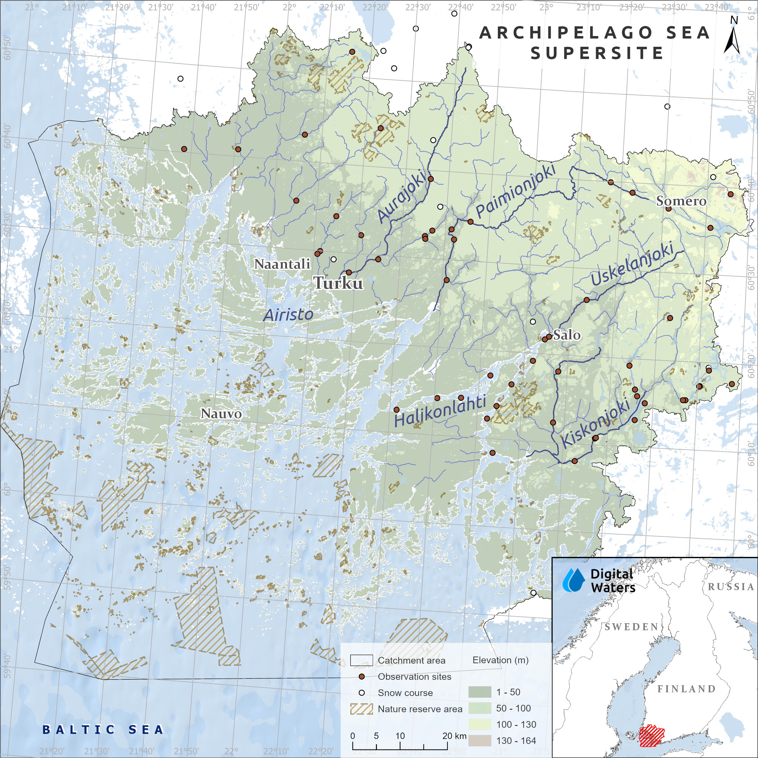
The Archipelago Sea in southwestern Finland is unique because of its thousands of islands, islets, and skerries. The Supersite consists of the Archipelago Sea and its catchments.
The Archipelago Sea has been recognized as a national priority in Finland, with policy measures focusing on reducing nutrient loading, particularly from agriculture, to mitigate eutrophication. The aim of the governmental Archipelago Sea Programme is to remove the area from the HELCOM list of nutrient pollution hotspots in the Baltic Sea.
The Archipelago Sea Supersite is a multidisciplinary research platform dedicated to understanding how land use, environmental change, and water management influence the archipelago. Research focuses on quantifying nutrient, sediment, and pollutant loads transported from catchments to the Archipelago Sea, identifying their sources, pathways, and impacts on coastal ecosystems.
The supersite also supports the development and testing of sustainable agricultural and urban water management practices, while assessing the effects of climate change and the potential of nature-based solutions to improve water quality and strengthen resilience. Close collaboration with landowners, farmers, authorities, and other stakeholders supports the effective implementation of measures.
Aurajoki & its tributary Savijoki
The Aurajoki River catchment is characterized by intensive agricultural land use, with large areas of cultivated fields contributing substantial nutrient and sediment loads to the river system and ultimately to the Archipelago Sea. The Aurajoki flows through the city of Turku, and the Port of Turku, one of Finland’s most important maritime hubs, is located at its estuary.
The river’s water quality is typically turbid and nutrient-rich due to extensive clay soils and agricultural runoff. Within the Aurajoki catchment, and especially in its tributary Savijoki, our research focuses on nature-based water retention measures, climate resilience, and sustainable agricultural water protection.
We collaborate with local stakeholders and landowners to improve understanding of water management challenges and opportunities across the catchment. We integrate local knowledge with hydrological modelling to identify sustainable and locally relevant water management strategies.
Uskelanjoki, Halikonjoki & Halikonlahti estuary
The Uskelanjoki–Halikonjoki river system and the Halikonlahti estuary provide a unique opportunity to study water flow, nutrient transport, and ecological processes across the land-sea continuum. The catchments are dominated by agricultural landscapes and naturally nutrient-rich clay soils, making the area particularly sensitive to erosion and nutrient loading.
The Halikonlahti estuary is prone to eutrophication and seasonal oxygen depletion due to high nutrient inputs from the surrounding catchments. These conditions can increase internal nutrient loading and further affect water quality.
Research in the area focuses on tracking the sources, transport, and fate of nutrients, sediments, and dissolved organic matter, as well as understanding the environmental processes that regulate them. Long-term monitoring also helps assess how climate change may alter hydrological conditions, ice cover, and seasonal runoff patterns, and what these changes mean for the future health of both river and coastal ecosystems.
Fluxes and pressures
Analysis of nutrient, sediment, and material fluxes from source to sea under changing climate and land-use conditions.
Data integration
Integration of long-term monitoring, computational modelling, remote sensing, field observations, and citizen science data.
Monitoring networks
Development and harmonization of regional monitoring networks to support targeted water protection measures.
Nature-based solutions
Exploring nature-based solutions for reducing nutrient runoff and improving water quality.
Stakeholder engagement
Incorporating landowner and farmer perspectives into the design and implementation of management measures.
- Intensive land use, especially agriculture, drives high nutrient loading from the catchment to the Archipelago Sea.
- Ecological status is degraded, with eutrophication, biodiversity loss, and oxygen depletion being the main challenges.
- Climate change increases water temperatures and intensifies extreme events, such as winter runoff, exacerbating eutrophication.
- Limited and fragmented data hinder effective targeting water protection measures.