
Sopitta Thurachen, University of Turku, sopitta.thurachen@nls.fi, sopitta.s.thurachen@utu.fi
Rivers are vital ecosystems, but climate change is causing them to evolve rapidly. Monitoring how the land around rivers changes over time is critical for understanding erosion patterns, tracking shifts in flow patterns, and predicting flood risks. Accurate land cover maps of riverbanks and river corridors give researchers and decision-makers the data they need to protect these environments before it’s too late.
Why Deep Learning?
Deep learning offers a powerful way to automate the classification of land cover types such as sand, gravel, and low vegetation directly from remote sensing data. The advantages are considerable. Deep learning models can process large datasets far more quickly than manual mapping methods, making it possible to map river systems at scale in a fraction of the time. However, despite this promise, applying deep learning to land cover mapping, particularly in riverine environments, comes with its own set of challenges:
Limited and imbalanced training data
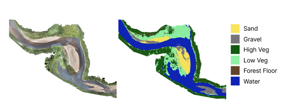
Riverine environments are highly complex. Some land cover classes, such as water or tall vegetation, tend to dominate the landscape, while others, like sand and gravel, appear only in small patches. This imbalance in the training data can make it difficult for models to learn useful patterns for the underrepresented classes, which often leads to poorer classification performance for these important but rare features.
Data annotation
Creating high-quality ground truth labels is another major bottleneck. Producing reliable training data is time-consuming and typically requires domain expertise in riverine environments. Annotating point cloud data directly is particularly challenging, so annotations are often created using 2D imagery instead. However, sediment classes beneath shallow water can be difficult to distinguish from orthophotos alone, and field visits may sometimes be necessary to verify the correct labels.
Domain shifts across sites and seasons
A model trained on data from one river system or one season does not always generalize well to others. Differences in geography, seasonal conditions, and even variations between sensors used in different data collections can lead to what is known as domain shift. In such cases, the patterns learned by the model no longer align well with the new data, reducing its accuracy.
Looking forward
Despite these challenges, the field is advancing rapidly. New model architecture, improved data annotation strategies, and emerging approaches such as few-shot and zero-shot learning are beginning to address many of these limitations. Together, these developments are bringing us closer to building robust frameworks capable of supporting real-world riverine environmental monitoring and informed decision-making.
In the big picture, I am working on riverine land covers and underwater mapping on multispectral point clouds. If you are interested in collaborating or having a chat. Feel free to reach out at sopitta.thurachen@nls.fi or sopitta.s.thurachen@utu.fi
6.3.2026