Jiahui Qiu, University of Oulu, Jiahui.Qiu@oulu.fi
Driven by a long-standing passion for cryospheric hydrology, I travelled from the warm coastal city of Shenzhen in southern China (just below the Tropic of Cancer) to northern Finland to pursue my PhD at the University of Oulu. My doctoral research is carried out under the Digital Waters doctoral education pilot. In my research, I focus on real-time river ice prediction through integrated remote sensing and monitoring.
River Ice in Finland: Importance and Monitoring Challenges
River ice is a defining feature of high-latitude hydrological systems. Around 56% of rivers in the Northern Hemisphere experience ice cover for part of the year, and in Finland, rivers undergo a pronounced annual freeze, the thaw cycle. The timing, duration, and extent of seasonal river ice cover have substantial ecological and socio-economic implications, influencing winter transportation, flood risk, hydropower operations, and aquatic ecosystems.
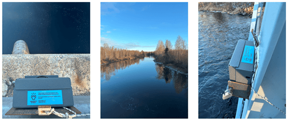
Monitoring river ice in Finland is not straightforward. Many rivers are small and narrow, making them difficult to observe using standard satellite-based Earth observation methods, which are often designed for larger water bodies. As a result, ice conditions can be missed or poorly resolved. To overcome this challenge, our team, working within the Cryosphere Research Infrastructure (CRYO-RI) initiative, installed shore-based cameras along the Kiiminkijoki River near its outlet to the Gulf of Bothnia. These cameras provide a simple but effective way to track river ice conditions at a local scale and throughout the winter season.
Our longer-term goal in the CRYO-RI initiative is to connect the camera-based monitoring framework with Finland’s broader observational ecosystem. In particular, we aim to integrate this system with the national camera network operated by the Finnish Environment Institute (Syke) and the Finnish Meteorological Institute (FMI), as well as with the Image Processing Toolbox (FMIPROT) developed by FMI. Together, these resources could provide a valuable validation dataset for Earth observation products and support a scalable, near-real-time digital twin system for river ice information and decision-making.
Expanding Cryosphere Research: From Rivers to Glaciers
Beyond studying river ice, my expertise in environmental remote sensing and advanced deep learning opens up opportunities to contribute to a wider range of cryospheric research. This includes applications such as monitoring polar glaciers, understanding sea-ice variability, and supporting the conservation of fragile ice environments. My work within the DIWA project is inherently interdisciplinary: my PhD research not only benefits from collaboration with experts in hydrological and climate modeling, but also actively contributes to these collaborations. By integrating remote sensing data and AI techniques with sophisticated modeling, we aim to develop robust digital twin architectures—virtual representations of real-world water systems—that can inform water-security solutions. These tools are designed to advance scientific understanding while also addressing practical societal needs, such as flood management, hydropower optimization, and climate-resilient infrastructure planning.
20.1.2026