Seyed Mahdi Jafari Mohammadi, Aalto University. seyed.jafarimohammadi@aalto.fi
Floodplain vegetation does far more than add greenery to riversides. It slows down water, stabilizes riverbeds and banks, traps sediment and nutrients, and creates habitats for fish and other species [1], [2]. These vegetation-flow-sediment interactions are essential for flood management, river engineering, and ecological health. Yet, despite decades of study, much of what we know comes from small-scale experiments. Translating those findings into the messy reality of natural floodplains, with their irregular vegetation, shifting sediments, and variable flows, remains a major challenge.
My doctoral research at Aalto University is designed to bridge this gap. I investigate how different vegetation arrangements influence flow resistance through controlled flume experiments, and how vegetation modifies sediment transport and deposition in real floodplain environments. By combining these approaches, I aim to develop and validate models that can scale from individual plants to entire floodplain sections. Ultimately, the goal is to improve predictions for flood resilience, sediment management, and ecosystem functioning, providing a stronger foundation for nature-based solutions in river systems.
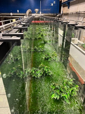
A River Floodplain in the Lab
In the Aalto Environmental Hydraulics Lab, I have the chance to recreate a river floodplain at a smaller, controllable scale. Using a 16-meter flume, I arrange synthetic plants to simulate natural vegetation patches—varying their width and density to represent a range of real-world conditions. By adjusting their shape, density, and then running water through at different speeds and depths, I can measure how these variables affect drag forces, turbulence, and flow resistance.
The strength of the lab is its precision. I can repeat the same experiment repeatedly, altering just one detail at a time, and observe how the flow responds. This allows me to untangle the mechanics of vegetation-flow interactions, something that is nearly impossible to isolate in nature, where countless factors change at once.
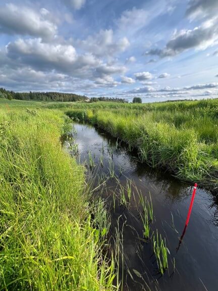
The field observations
Out in the Raasepori River floodplain, the research takes on a different character. Here, there are no controlled walls or steady pumps, just meandering channels, uneven plant growth, and the unpredictability of weather and floods. Instead of synthetic vegetation, I work among patchy vegetation, grasses, and herbs that grow in irregular clusters along the riverbanks.
In this natural setting, I measure how vegetation alters both flow and sediment transport. Sediment traps and sensors are placed across the floodplain to capture where material settles during high flows. I surveyed vegetation structure and water levels to see how plants redirect currents and change the pathways of suspended sediments. These observations reveal how vegetation influences floodplains at larger scales, where variability and complexity dominate.
Modeling and Bridging the scales
Neither the flume nor the field alone can tell the full story. The lab gives me clarity, the field gives me realism, but what I need is a way to connect them. That is where modeling comes in. By combining results from controlled experiments with observations from natural floodplains, I build models that describe how vegetation influences flow resistance and sediment transport across different scales. These models are tested against field data to see whether patterns discovered in the lab remain valid when applied to complex, living rivers.
The goal is to create tools that can scale up, from a single vegetation patch to entire floodplain sections. Such models can help predict how vegetation will affect flood levels, where sediments are likely to accumulate, and what this means for river restoration and habitat quality. In this way, modeling becomes the bridge: linking the precision of the laboratory with the complexity of the field and turning research into something river managers and ecologists can use in practice.
References
- P. M. Rowiński, K. Västilä, J. Aberle, J. Järvelä, and M. B. Kalinowska, “How vegetation can aid in coping with river management challenges: A brief review,” Ecohydrology & Hydrobiology, vol. 18, no. 4, pp. 345–354, Dec. 2018, doi: 10.1016/j.ecohyd.2018.07.003.
- K. Västilä and J. Järvelä, “Characterizing natural riparian vegetation for modeling of flow and suspended sediment transport,” J Soils Sediments, vol. 18, no. 10, pp. 3114–3130, Oct. 2018, doi: 10.1007/s11368-017-1776-3.
8.10.2025.