Emmy Kärkkäinen, University of Turku. emmy.karkkainen@utu.fi
Underwater Habitat Mapping
An underwater habitat is an area within a water body where organisms—such as fish, aquatic plants, and microorganisms—live and have adapted to local conditions. Such habitats form when the physical, chemical, and biological characteristics of a specific area allow organisms to thrive.
In river environments, habitat formation is particularly influenced by hydro-morphological factors, including:
- Flow conditions
- River continuity
- Variations in channel width and depth
- Flow velocities
- Substrate structure and quality
- Riparian zone structure
Knowledge of habitat types, location, and extents helps protect species and nature. Such knowledge can reduce the impact of human activities (e.g., eutrophication or hydraulic engineering) on ecosystems and safeguard ecosystem services. For example, fishing and fisheries depend on certain habitat types, as fish require specific conditions for spawning and rearing. It also supports sustainable land and water use planning, as well as the preservation of cultural heritage.
Despite the significance of such knowledge, underwater habitats are still only partially understood. Studying underwater habitats in rivers is particularly challenging due to the nature of flowing water and sediment dynamics, which continuously alter habitat conditions. Moreover, different river reaches challenge both researchers and research equipment; deep and fast-flowing sections can be hazardous, even dangerous, while shallow sections may not be deep enough for using measuring devices.
2D Hydraulic Modeling
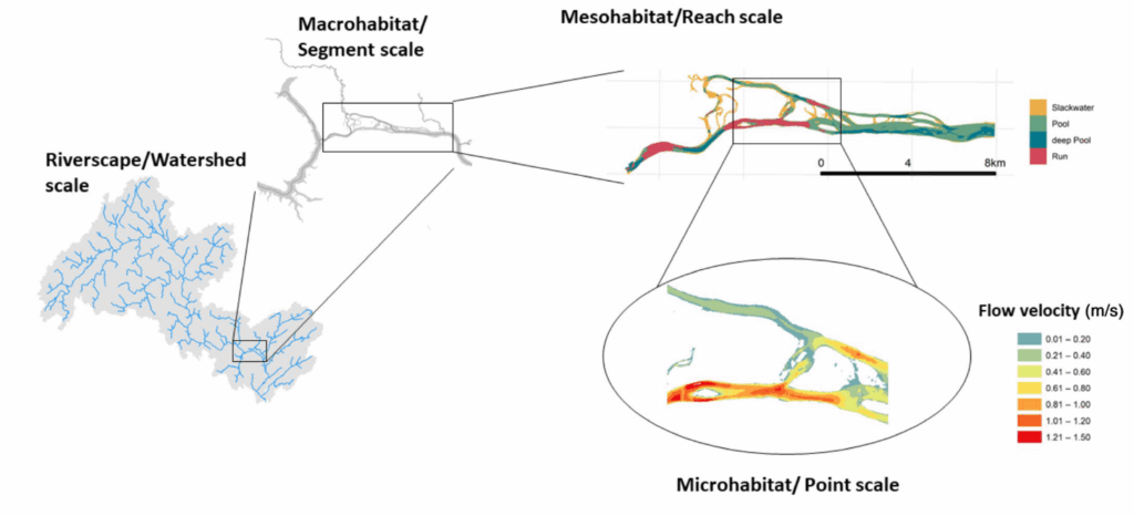
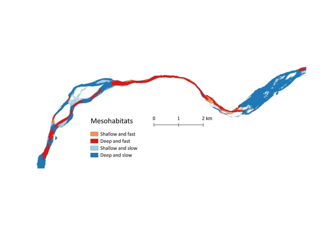
Two-dimensional (2D) hydraulic modeling is a powerful tool for mapping underwater habitats. The hydraulic model uses simplified equations to simulate water flow in a river; in other words, it simulates water surface elevations and gradients, depths, flow velocities and Froude numbers, for example. These parameters can be used to identify mesohabitats. Modeling enables the scaling of microhabitats (point scale) to mesohabitats (reach scale), and sometimes even to macrohabitats (segment or watershed scale).
Creating a 2D hydraulic model involves overcoming two major challenges:
- Obtaining terrain and bathymetric data that is spatially comprehensive
- Ensuring that the spatial data is sufficiently accurate
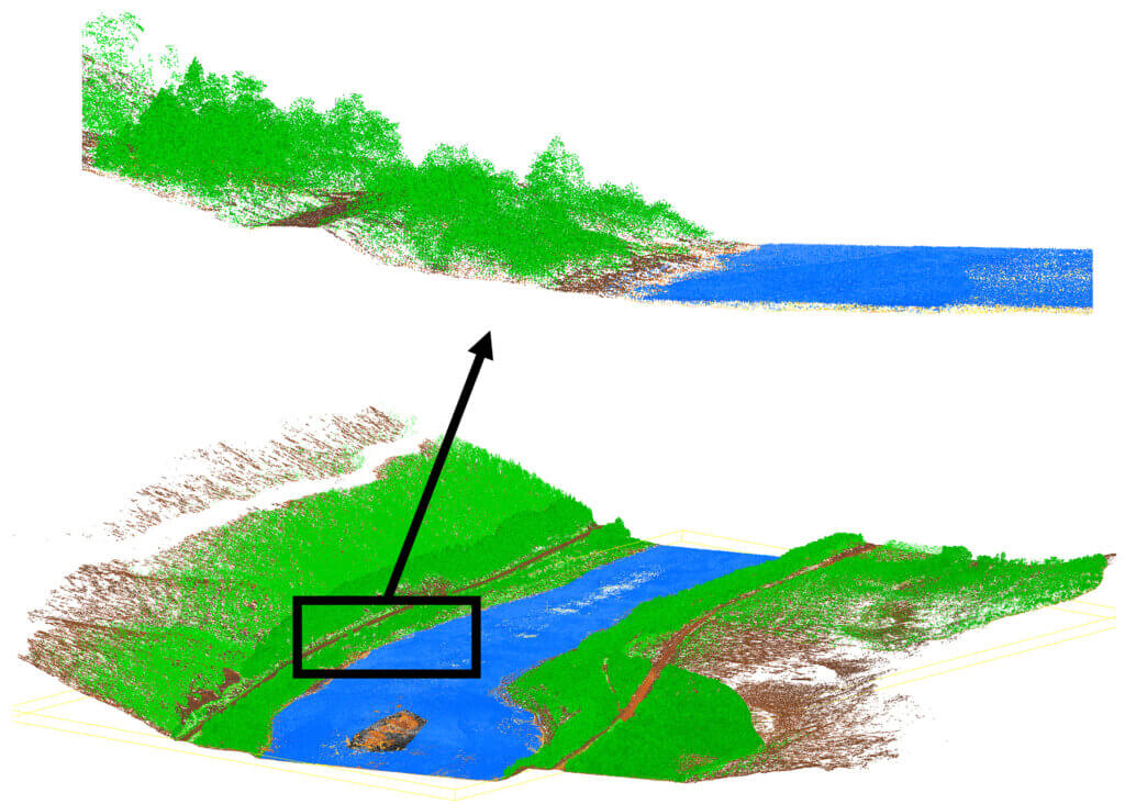
In practice, the lack of a high-quality, spatially complete digital terrain model (DTM) often limits the use of 2D hydraulic modeling. Remote sensing has long been used to obtain accurate spatial data, and airborne laser scanning (ALS) is among the most precise technologies available. Unlike satellite or aerial imagery, ALS is unaffected by clouds or shadows. A scanner mounted on a helicopter or airplane can capture data over hundreds of kilometers in a short time without any contact with the water.
Traditional near-infrared (NIR) lasers in topographic scanners, however, cannot capture river bathymetry. The laser beams are reflected from the water surface rather than penetrating through it. Consequently, ALS data is often paired with sonar data—ALS covering floodplains and sonar covering the riverbed. However, this method loses the many advantages of ALS. Furthermore, collecting sonar data is not always possible; in shallow areas, the depth is simply insufficient for using the measuring device. Thus, the integration of ALS and sonar datasets may not yield a fully continuous DTM across the entire river reach.
Multispectral Airborne Laser Scanning
Multispectral ALS is a relatively new development (Ahokas et al., 2016) with strong potential for hydraulic 2D modeling. Collecting spatial data at more than one wavelength, one of which is green (532 nm), at the same time, enables simultaneous high-resolution spatial data collection of both the terrain above water and the riverbed below. This means that a single survey can produce data on river bathymetry, water surface elevation, and floodplain topography.
The Optech Titan, launched in 2014 by Teledyne Optech (Bakuła, 2015), was the first commercial multispectral laser scanner. Even today, only a few service providers operate such systems. The Finnish Geospatial Research Institute (FGI) has developed a helicopter-based HeliALS-TW system. This system uses three Riegl scanners (Riegl GmbH, Austria): VUX-1HA, miniVUX-3UAV, and VQ-840-G with wavelengths of 1550 nm, 905 nm, and 532 nm, respectively. To date, most HeliALS-TW studies have focused on forest applications (Hakula et al., 2023; Muhojoki et al., 2024). The exploration of its potential in aquatic environmental research remains at an early stage. In our study, the spatial data collected with the HeliALS-TW system plays a key role.
Mapping Atlantic Salmon Mesohabitats in the Tana River
Our study investigates how multispectral ALS and 2D hydraulic modeling can be combined to map mesohabitats for Atlantic salmon in the subarctic Tana River, which flows along the Finland–Norway border. In Norway, mesohabitats in salmon rivers are typically classified using field observations, simple measurements, and a decision tree with hydraulic threshold values as criteria limits (Borsányi et al., 2004). While widely used, this approach has limitations (Wyrick et al., 2014):
- Thresholds between hydraulic variables and habitat types can be difficult to identify visually in the field
- Point measurements may not capture temporal variability
- Subtle differences between habitat classes are hard to distinguish visually
- The boundaries between habitat units can be difficult to define consistently
Still, with minor modifications, Borsányi’s decision tree approach can be applied to the mesohabitats classification based on the results of 2D hydraulic models. Modeling offers several advantages: it reduces subjectivity, allows for more precise habitat delineation, and accounts for changing flow conditions. Furthermore, the simulations can be easily repeated and updated, and parameters adjusted.
In our work, multispectral ALS data was used to generate a high-resolution DTM for the 2D hydraulic model. After that, the model was combined with over 60 years of daily discharge and water-level data. The model results allow us to map salmon mesohabitats in the Tana River with unprecedented spatial resolution and to simulate how changes in discharge affect habitat occurrence, location, and extent.
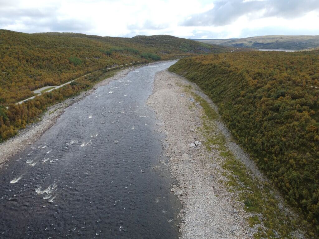
The Tana River is an ideal study site: it is a large, clear, and moderately shallow subarctic river with one of the world’s most genetically diverse Atlantic salmon populations (Erkinaro et al., 2019; Vähä et al., 2017). However, the salmon population has declined significantly in recent years (Anon 2025), which, on the other hand, makes mapping the salmon mesohabitats extremely interesting. The mesohabitat maps generated in this research will be valuable for biologists, ecologists, hydrologists, geographers, planners, and those working in ecosystem-based industries. As part of Digital Waters Flagship’s goal of digitizing Finnish water systems, this study brings salmon habitat assessment in the Tana River into the new digital age.
Moreover, the combination of multispectral ALS and hydraulic modeling has applications beyond habitat mapping—for example, creating virtual environments for training underwater robots before deployment in real rivers.
References
- Ahokas, E., Hyyppä, J., Yu, X., Liang, X., Matikainen, L., Karila, K., Litkey, P., Kukko, A., Jaakkola, A., Kaartinen, H., Holopainen, M., Vastaranta, M., 2016. Towards Automatic Single-Sensor Mapping by Multispectral Airborne Laser Scanning. The International Archives of the Photogrammetry, Remote Sensing and Spatial Information Sciences XLI-B3, 155–162. https://doi.org/10.5194/isprs-archives-XLI-B3-155-2016
- Bakuła, K., 2015. Multispectral Airborne Laser Scanning – a New Trend in the Development of Lidar Technology. Archiwum Fotogrametrii, Kartografii i Teledetekcji 27, 25–44. https://doi.org/10.14681/afkit.2015.002
- Borsányi, P., Alfredsen, K., Harby, A., Ugedal, O., Kraxner, C., 2004. A Meso-scale Habitat Classification Method for Production Modelling of Atlantic Salmon in Norway. Hydroécol. Appl. 14, 119–138. https://doi.org/10.1051/hydro:2004008
- Erkinaro, J., Czorlich, Y., Orell, P., Kuusela, J., Falkegård, M., Länsman, M., Pulkkinen, H., Primmer, C.R., Niemelä, E., 2019. Life history variation across four decades in a diverse population complex of Atlantic salmon in a large subarctic river. Can. J. Fish. Aquat. Sci. 76, 42–55. https://doi.org/10.1139/cjfas-2017-0343
- Hakula, A., Ruoppa, L., Lehtomäki, M., Yu, X., Kukko, A., Kaartinen, H., Taher, J., Matikainen, L., Hyyppä, E., Luoma, V., Holopainen, M., Kankare, V., Hyyppä, J., 2023. Individual tree segmentation and species classification using high-density close-range multispectral laser scanning data. ISPRS Open Journal of Photogrammetry and Remote Sensing 9. https://doi.org/10.1016/j.ophoto.2023.100039
- Muhojoki, J., Hakala, T., Kukko, A., Kaartinen, H., Hyyppä, J., 2024. Comparing positioning accuracy of mobile laser scanning systems under a forest canopy. Science of Remote Sensing 9. https://doi.org/10.1016/j.srs.2024.100121
- Vähä, J.-P., Erkinaro, J., Falkegård, M., Orell, P., Niemelä, E., 2017. Genetic stock identification of Atlantic salmon and its evaluation in a large population complex. Can. J. Fish. Aquat. Sci. 74, 327–338. https://doi.org/10.1139/cjfas-2015-0606
- Wegscheider, B., Linnansaari, T., Curry, R.A., 2020. Mesohabitat modelling in fish ecology: A global synthesis. Fish and Fisheries 21, 927–939. https://doi.org/10.1111/faf.12477
- Wyrick, J.R., Senter, A.E., Pasternack, G.B., 2014. Revealing the natural complexity of fluvial morphology through 2D hydrodynamic delineation of river landforms. Geomorphology 210, 14–22. http://dx.doi.org/10.1016/j.geomorph.2013.12.013
22.8.2025.