Authors: Juha Oksanen, Elizabeth Carter, Mohammad Imangholiloo, Pyry kettunen & Ville Mäkinen
Water-related geospatial data is one of the core components of hydrological models. Digital elevation models and their derivatives, including catchment areas, are critical data when modelling, for example, runoff and sediment transport. River networks form the “blood vessels” of many different hydrological models. Land cover and soil data are needed when estimating infiltration and evapotranspiration in water balance calculations or when modelling groundwater accumulation. In marine environments, data describing ocean currents are needed when simulating the spread of nutrients or pollutants. In-situ sensor data provide important real-time information on the responsiveness of the hydrological system to local weather conditions.
There is an extensive amount of openly available geospatial data on aquatic environments on the internet. Global open data on marine environments can be found, for example, in the European Marine Observation and Data Network (EMODnet) services and Copernicus Marine services. The most substantial collection of data on the Baltic Sea is compiled in the HELCOM Map and data service. Data on freshwater environments can be found, for example, in the Copernicus Land Monitoring and Finnish Environment Institute data services.
Despite the rich supply of open data on the internet, the biggest obstacles to its effective use are findability, interoperability, and accessibility of the data. It is very difficult for researchers to know where data is available, how it can be accessed technically, and what needs to be done with the data to use it correctly. Geospatial data related to freshwater environments is scattered across a large number of national and local data services. The format and quality of metadata records vary, and technical documentation related to the usability of the data is often limited. In addition, data services and user interfaces rep freshwater and marine environments are often isolated, and seamless access to data in these different environments is not possible.
Integration challenges in geospatial data on aquatic environments
Integrating geospatial data from marine and freshwater environments poses significant challenges, as these domains often rely on different standards, data collection methods, and modeling approaches across varying spatial and temporal scales. The following section highlights common interoperability issues encountered with geospatial data for aquatic environments. For clarity, these issues are categorized according to the European Interoperability Framework into four dimensions: technical, semantic, legal, and organizational.
Geographic data is typically collected and presented using the coordinate system most appropriate for the specific dataset, which may be global, continental, national, or local in scope. Differences in vertical datums between marine and freshwater environments further complicate comparisons of elevation measurements, as accurate conversion between datums is required. In raster datasets, incompatible grid structures—such as differing origins or pixel sizes—often necessitate resampling. Additionally, file formats may range from widely recognized standards to highly customized proprietary formats. Temporal discrepancies also pose a challenge, as datasets representing different points in time can produce misleading results if combined without careful consideration. Collectively, these factors constrain the technical interoperability of the data.
While addressing technical challenges remains relatively straightforward, the more significant obstacles concern the interoperability of the data content itself, known as semantic interoperability. This concept arises when the same real-world feature is represented differently across databases. For example, a river is labelled as “river” in an English database, “älv” in a Swedish database, “Fluss” in a German database, and “rivière” in a French database. Furthermore, in English datasets, the term “basin” can refer either to a marine region, such as the Atlantic Basin, or to a freshwater drainage basin, depending on the context.
Legal interoperability primarily concerns the licensing terms associated with data and the opportunities or restrictions these terms impose. While the use and distribution of data for marine areas are often governed by global licensing frameworks, legislation, and licenses, for freshwater environments are typically determined at the national level. Organizational interoperability, on the other hand, refers to the extent to which organizational policies and procedures facilitate data sharing. In the context of water-related data, this is a key factor contributing to functional silos, as authorities managing marine and freshwater environments generally do not produce interoperable datasets.
Addressing Interoperability Challenges in Water-Related Data
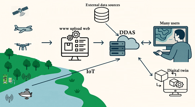
The Digital Waters flagship, EOSC, AquaINFRA, and SEADITO projects are developing pilot services aimed at enhancing data interoperability for the hydrologic research community. These services enable seamless searches across numerous external open metadata sources and provide direct access to data through the Open Geospatial Consortium’s (OGC) open interface solutions. The search functionality is implemented as a federated service, meaning that metadata is retrieved in real time rather than being harvested into a centralized repository in advance. This approach ensures that the metadata remains current and up to date.
A central component of the services is the Data Discovery and Access Service (DDAS), which leverages external open data sources. In addition, the DIWA service package includes a Data Lake built on CSC’s data storage infrastructure. This platform is designed to store and distribute data during the active research phase, where proximity to geocomputing resources is essential. The DIWA package will also integrate Zenodo and the EUDAT B2SHARE service, which serve as repositories for highly refined and curated datasets, both providing permanent identifiers for shared materials. Of particular significance to the DIWA project is the integration of real-time data from IoT (Internet of Things) sensor networks into the service package. The DDAS, together with the Data Lake and the Virtual Research Environments to be established within CSC’s computing infrastructure, will play a crucial role in enabling the creation of digital twins of freshwater environments as part of the DIWA flagship project.
The interoperability of the technical solutions developed within the projects is guided by the principles of the European Interoperability Framework, with particular emphasis on openness, transparency, reusability, technological neutrality, and user-centricity. All solutions are built upon extensive open data resources, employ open-source tools, and are themselves distributed as open-source software. The development of these solutions is driven by the actual needs of end users, as identified through the projects’ user requirement studies. The projects will also demonstrate various workflows based on implemented use cases, including real-time web interfaces, as well as virtual and extended reality geovisualizations and dashboards.
16.12.2025.